Digital Program
LANDSCAPE I
The piece is divided into six parts, each inspired by a photograph. These images depict different locations across Japan and are titled using geographic coordinates. Each set of coordinates marks the exact location where the photograph was taken. Listeners are encouraged to enter these coordinates into Google Maps and explore the sites through Street View, offering a visual counterpart to the music.
The piece is divided into six parts, each inspired by a photograph. These images depict different locations across Japan and are titled using geographic coordinates. Each set of coordinates marks the exact location where the photograph was taken. Listeners are encou to enter these coordinates into Google Maps and explore the sites through Street View, offering a visual counterpart to the music.
Landscape I uses 6 channel audio to create a fully spacial experience, inviting the audience to be among the performers for full immersion. This effect is achieved through multichannel panning, delays, and backing tracks that gradually shift over the course of an hour.
Landscape I is an evening length ambient work for percussion duo and electronics that attempts to take listeners through an immersive listening experience inspired by 6 images.
Landscape I is an evening length ambient work for percussion duo and electronics that attempts to take listeners through an immersive listening experience inspired by 6 images.
Landscape I uses 6 channel audio to create a fully spacial experience, inviting the audience to be among the performers for full immersion. This effect is achieved through multichannel panning, delays, and backing tracks that gradually shift over the course of an hour.
Each photograph is paired with a distinct musical environment, ranging from natural sounds to complex polyrhythmic textures performed on keyboard instruments.
Each photograph is paired with a distinct musical environment, ranging from natural sounds to complex polyrhythmic textures performed on keyboard instruments.
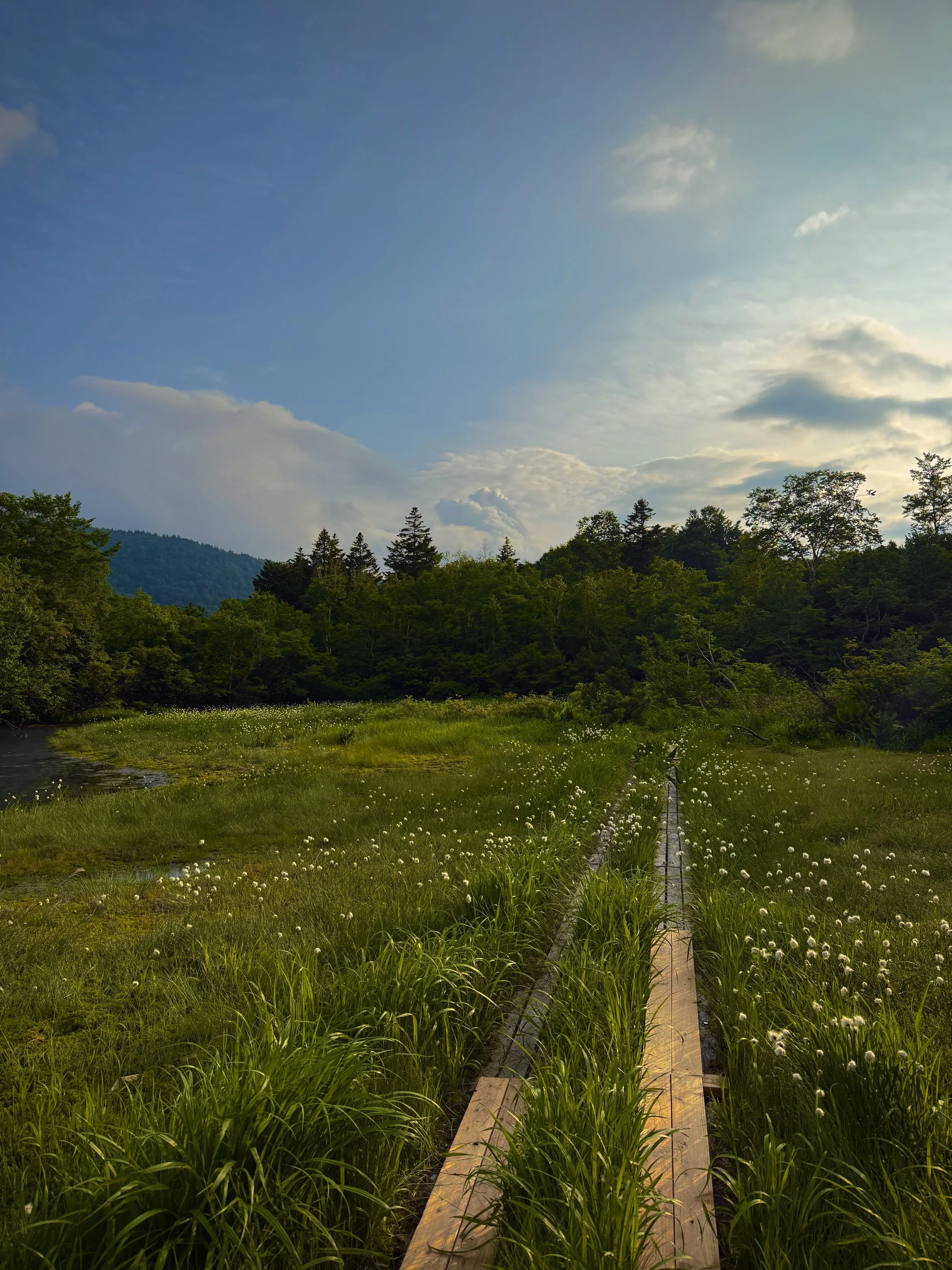
Mount Iwaki (岩木山, Iwaki-san) is a striking volcanic mountain in Aomori Prefecture, in the northern part of Honshu. It’s often called “Tsugaru Fuji” because its symmetrical cone resembles Mount Fuji. Mount Iwaki is deeply tied to the culture of the Tsugaru region. At its base is Iwaki Shrine, an important spiritual site. Every year, locals celebrate the Oyama-sankei festival, where people climb the mountain as a form of pilgrimage.
The music reflects the natural environment surrounding Iwaki Shrine, incorporating the calls of local bird species such as the Japanese green pheasant, Japanese woodpecker, Asian tit, Brown-eared Bulbul, and Meadow Bunting. Performers emulate sounds of trees and wind using a variety of instruments, creating an immersive environment.
40° 37’ 18.27” N 140° 20’ 25.362” E
Mt. Iwaki
Mt. Iwaki
40° 37’ 18.27” N 140° 20’ 25.362” E
Mount Iwaki (岩木山, Iwaki-san) is a striking volcanic mountain in Aomori Prefecture, in the northern part of Honshu. It’s often called “Tsugaru Fuji” because its symmetrical cone resembles Mount Fuji. Mount Iwaki is deeply tied to the culture of the Tsugaru region. At its base is Iwaki Shrine, an important spiritual site. Every year, locals celebrate the Oyama-sankei festival, where people climb the mountain as a form of pilgrimage.
The music reflects the natural environment surrounding Iwaki Shrine, incorporating the calls of local bird species such as the Japanese green pheasant, Japanese woodpecker, Asian tit, Brown-eared Bulbul, and Meadow Bunting. Performers emulate sounds of trees and wind using a variety of instruments, creating an immersive environment.
42° 33’ 57.498” N 140° 48’ 46.872” E
Lake Toya
Lake Toya
42° 33’ 57.498” N 140° 48’ 46.872” E
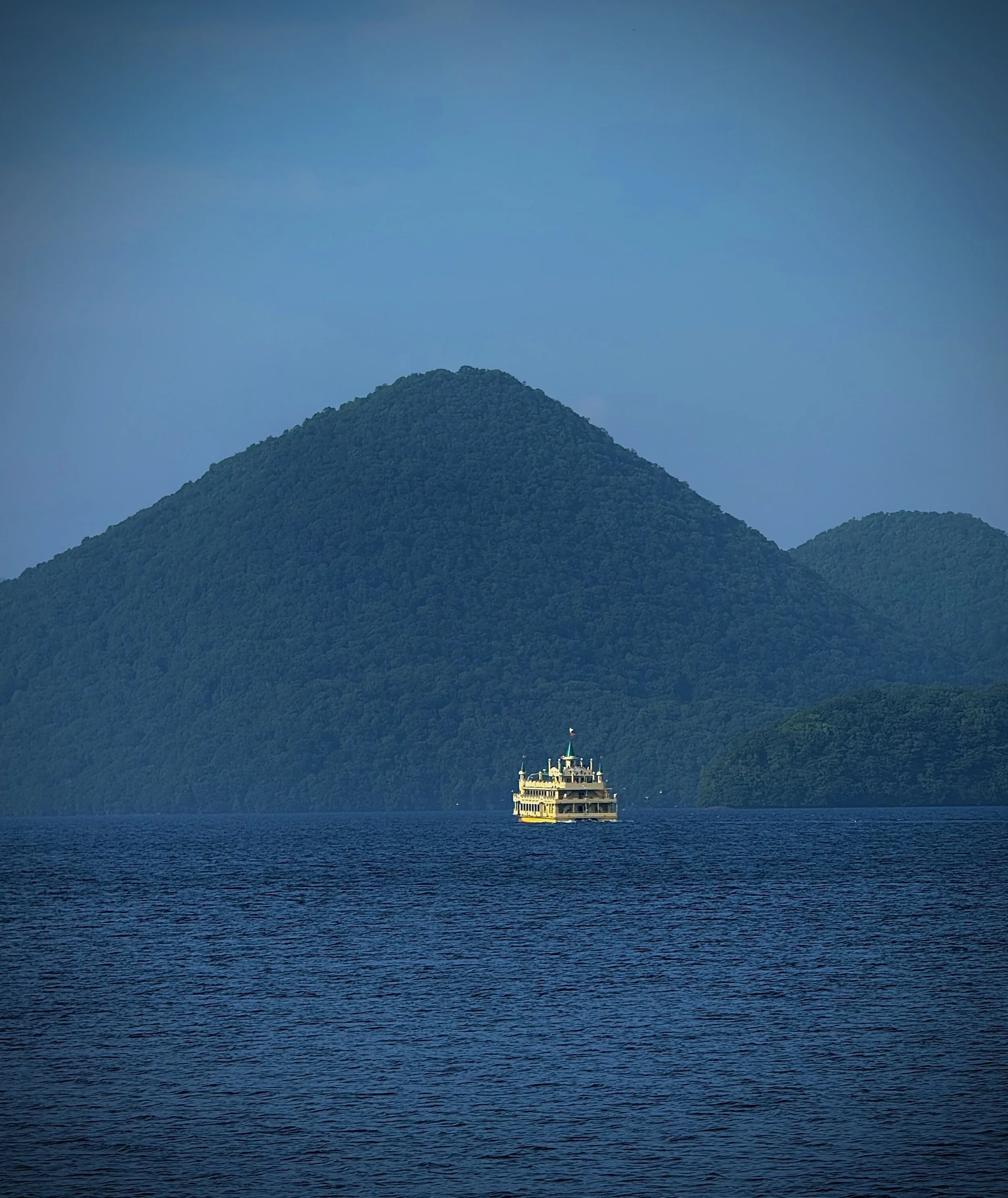
Lake Tōya (洞爺湖, Tōya-ko) is a beautiful caldera lake in Hokkaido, formed by volcanic activity thousands of years ago. It’s part of Shikotsu-Toya National Park and is known for its calm water, volcanic landscape, and year-round scenic views. At night, there are often fireworks over the lake reflecting beautifully on the water.
The music reflects water through overlapping vibraphone patterns that shift like a kaleidoscope. A backing track mimics the surrounding environment, while delayed bass figures echo a passing steamboat.
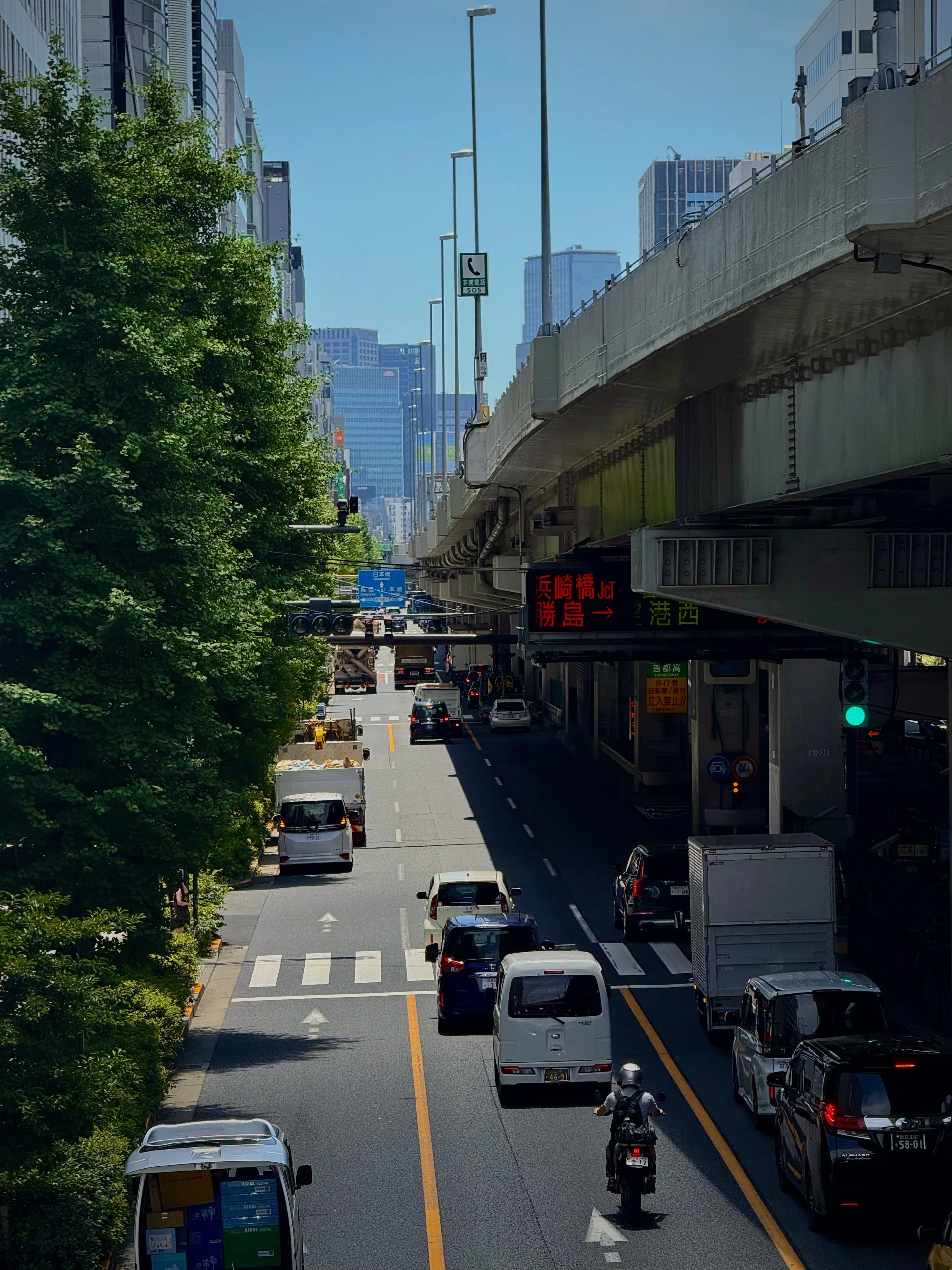
National Route 4 (Japan) is one of Japan’s major arterial highways, running from central Tokyo northward through the Tōhoku region all the way to Aomori. In Tokyo, much of Route 4 follows Shōwa-dōri, a broad, busy avenue that carries a constant flow of cars, buses, and freight traffic. At this location, the sound is defined by layers of engine noise, tire hum, and traffic flow, influenced by the surrounding architecture and elevated roadways.
The music is driving and layered, built from interlocking patterns performed on metal objects, flower pots, stone bars, and brake drums. These materials create a gritty, industrial sound that gradually intensifies, reinforced by drum textures in the backing track. Synthesizers weave in and out of the texture, bending in and out of tune to add tension and instability.
National Route 4
National Route 4
35° 42’ 38.178” N 139° 46’ 36.408” E
National Route 4 (Japan) is one of Japan’s major arterial highways, running from central Tokyo northward through the Tōhoku region all the way to Aomori. In Tokyo, much of Route 4 follows Shōwa-dōri, a broad, busy avenue that carries a constant flow of cars, buses, and freight traffic. At this location, the sound is defined by layers of engine noise, tire hum, and traffic flow, influenced by the surrounding architecture and elevated roadways.
The music is driving and layered, built from interlocking patterns performed on metal objects, flower pots, stone bars, and brake drums. These materials create a gritty, industrial sound that gradually intensifies, reinforced by drum textures in the backing track. Synthesizers weave in and out of the texture, bending in and out of tune to add tension and instability.
35° 42’ 38.178” N 139° 46’ 36.408” E
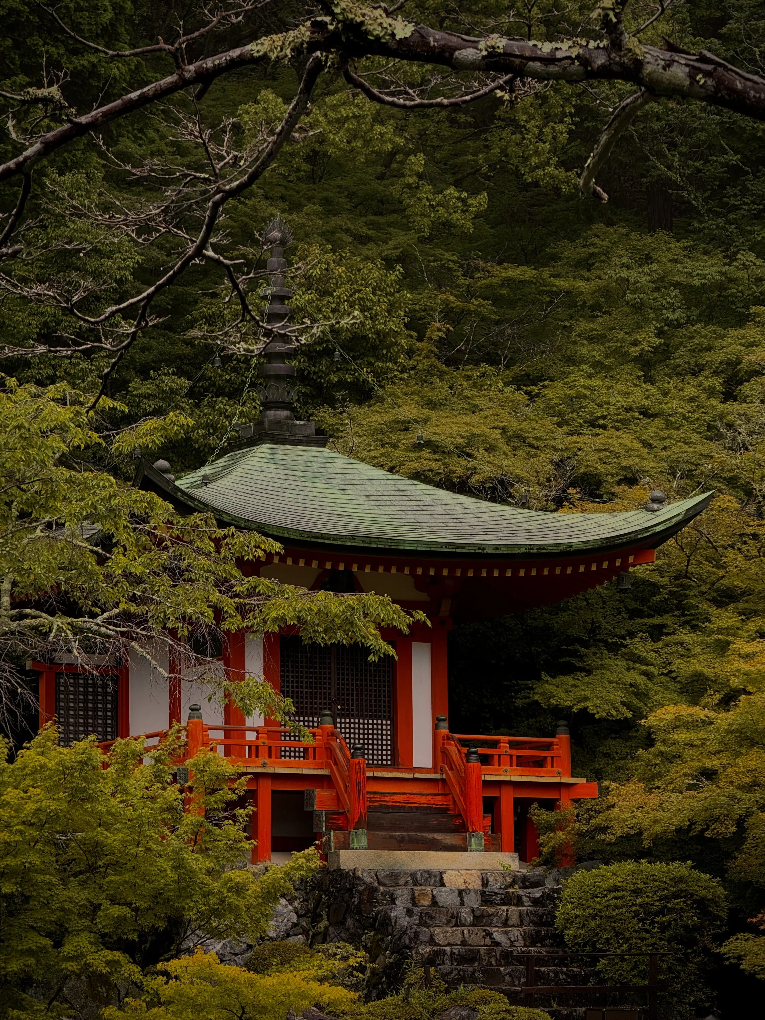
Sampō-in (三宝院) is a sub-temple of Daigo-ji in Kyoto, and is especially famous for its refined garden design and connection to samurai-era history. Sampō-in was originally established in the 12th century, but it’s most closely associated with Toyotomi Hideyoshi, one of Japan’s most powerful warlords. In 1598, he held an extravagant cherry blossom viewing party here (called Daigo no Hanami), bringing together hundreds of guests in a highly staged, almost theatrical event.
The music is uneasy, blending gongs, singing bowls, and other resonant metal objects with elongated delay effects to create a dark, shimmering texture representing kegare (穢れ), or spiritual impurity. This calm is suddenly broken by the strike of a bell, reflecting the Shinto ritual of harae (祓), or purification.
Sampo-In Temple
34° 57’ 3.078” N 135° 49’ 27.63” E
Sampo-In Temple
34° 57’ 3.078” N 135° 49’ 27.63” E
Sampō-in (三宝院) is a sub-temple of Daigo-ji in Kyoto, and is especially famous for its refined garden design and connection to samurai-era history. Sampō-in was originally established in the 12th century, but it’s most closely associated with Toyotomi Hideyoshi, one of Japan’s most powerful warlords. In 1598, he held an extravagant cherry blossom viewing party here (called Daigo no Hanami), bringing together hundreds of guests in a highly staged, almost theatrical event.
The music is uneasy, blending gongs, singing bowls, and other resonant metal objects with elongated delay effects to create a dark, shimmering texture representing kegare (穢れ), or spiritual impurity. This calm is suddenly broken by the strike of a bell, reflecting the Shinto ritual of harae (祓), or purification.
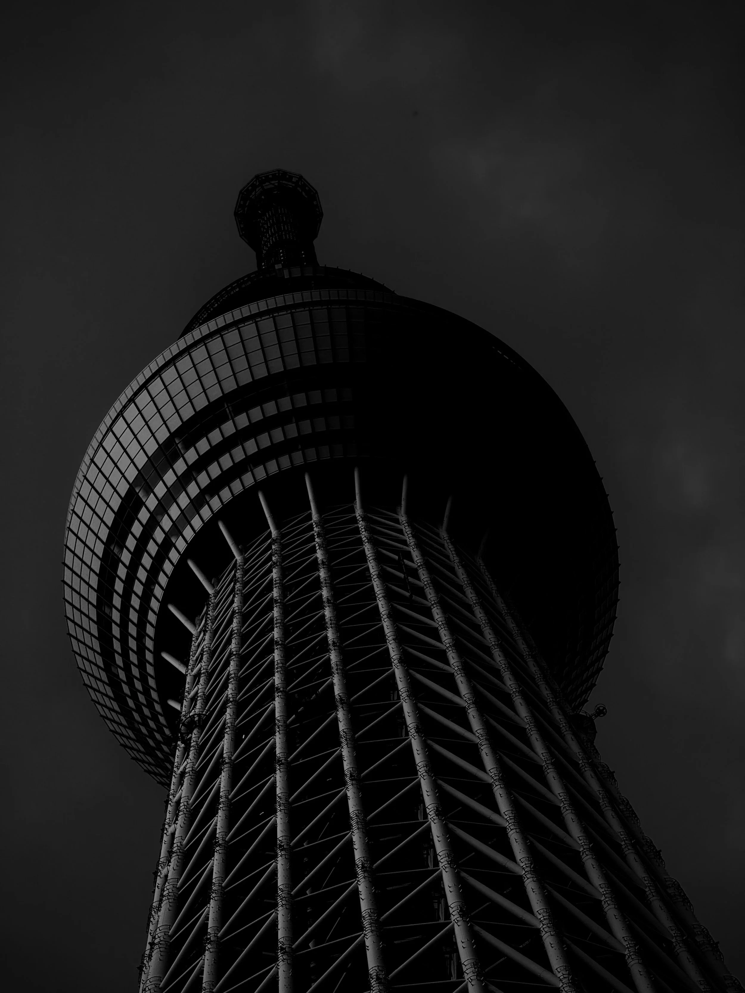
Tokyo Skytree is a broadcasting, restaurant, and observation tower in Tokyo, completed in 2012. At 634 meters, it is the tallest structure in Japan and the second-tallest tower in the world. Its name, “Skytree,” reflects its soaring height, while the number 634 was chosen because it can be read as “Musashi,” the historic name of the region.
The music is looming, with bowed vibraphone and reversed synth pads creating a sense that the listener is standing right at the base of the tower. The texture builds to an almost overwhelming density before dissolving into a series of downsampled synths and bowed vibraphone notes.
Tokyo Skytree
Tokyo Skytree
35° 42’ 37.59” N 139° 48’ 41.208” E
Tokyo Skytree is a broadcasting, restaurant, and observation tower in Tokyo, completed in 2012. At 634 meters, it is the tallest structure in Japan and the second-tallest tower in the world. Its name, “Skytree,” reflects its soaring height, while the number 634 was chosen because it can be read as “Musashi,” the historic name of the region.
The music is looming, with bowed vibraphone and reversed synth pads creating a sense that the listener is standing right at the base of the tower. The texture builds to an almost overwhelming density before dissolving into a series of downsampled synths and bowed vibraphone notes.
35° 42’ 37.59” N 139° 48’ 41.208” E

Botanical Garden
Botanical Garden
40° 38’ 51.462” N 140° 51’ 7.218” E
40° 38’ 51.462” N 140° 51’ 7.218” E
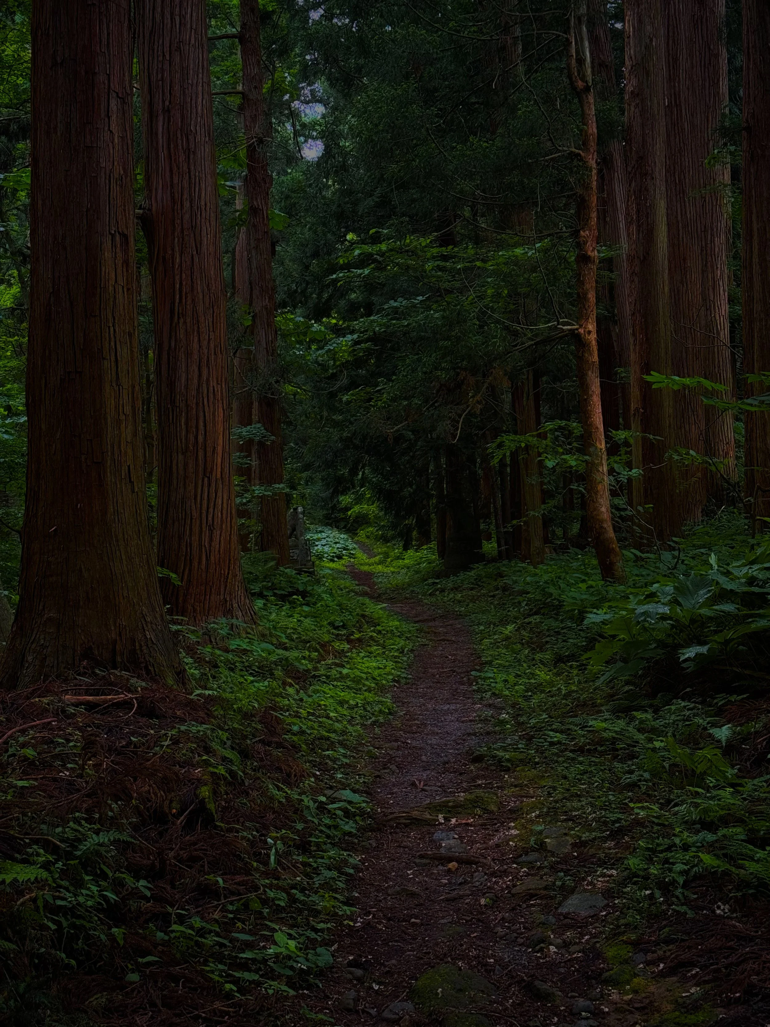
40° 38′ 51.462″ N 140° 51′ 7.218″ E, is in the northern Tōhoku region of Japan, near Lake Towada, one of Honshū’s most dramatic natural landscapes. Lake Towada (十和田湖, Towada‑ko) is a vast caldera lake formed in the crater of an ancient volcano and is among Japan’s deepest lakes, its brilliant blue waters surrounded by dense forests and rugged hills. The broader area is part of Towada‑Hachimantai National Park, which encompasses jagged peaks, waterfalls, and the scenic Oirase Stream valley, celebrated for its seasonal foliage and pristine wilderness.
The music draws on nostalgia, unfolding through slow, synth-pop–inspired chords that create a feeling of suspended time. Warm bass notes and rhythmic patterns on vibraphone and glockenspiel add brightness and movement. Together, these elements form a reflective sound that blends quiet intimacy with overwhelming emotion.